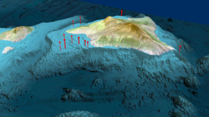
Home » Expedition 389 Hawaiian Drowned Reefs » Location of IODP Expedition 389 boreholes. The bathymetric (ocean depth) data is derived from the Main Hawaiian Island Bathymetric Data Synthesis dataset developed by the Hawai’i Mapping Research Group (http://www.soest.hawaii.edu/HMRG/cms/). A color shaded relief image was produced from a 2010 version of the HMRG dataset and a land/ocean mask was used to integrate the Landsat imagery and bathymetry into a single image. Source data: Landsat 7 (ETM) satellite imagery. Originator: Earthstar Geographics LLC”
Location of IODP Expedition 389 boreholes. The bathymetric (ocean depth) data is derived from the Main Hawaiian Island Bathymetric Data Synthesis dataset developed by the Hawai’i Mapping Research Group (http://www.soest.hawaii.edu/HMRG/cms/). A color shaded relief image was produced from a 2010 version of the HMRG dataset and a land/ocean mask was used to integrate the Landsat imagery and bathymetry into a single image. Source data: Landsat 7 (ETM) satellite imagery. Originator: Earthstar Geographics LLC”
Location of IODP Expedition 389 boreholes. The bathymetric (ocean depth) data is derived from the Main Hawaiian Island Bathymetric Data Synthesis dataset developed by the Hawai’i Mapping Research Group (http://www.soest.hawaii.edu/HMRG/cms/). A color shaded relief image was produced from a 2010 version of the HMRG dataset and a land/ocean mask was used to integrate the Landsat imagery and bathymetry into a single image. Source data: Landsat 7 (ETM) satellite imagery. Originator: Earthstar Geographics LLC”
